


SIMA Monitoreo de Cultivos
Description of SIMA Monitoreo de Cultivos
SIMA, short for Integrated Agricultural Monitoring System, is an application designed for monitoring agricultural fields in a systematic manner. Available for the Android platform, SIMA allows users to download a tool that simplifies the process of collecting and managing field data. This application is geared towards agricultural professionals and farmers seeking to enhance their monitoring capabilities with real-time data.
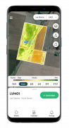
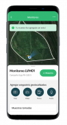
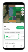
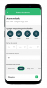
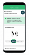
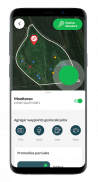
The primary function of SIMA is to facilitate the collection and geolocation of field data. Users can record various field conditions, including the presence of weeds, pests, and diseases. The app enables users to capture and store multimedia data such as photos, videos, and voice notes, which aids in comprehensive documentation of the field's status. This integration of multimedia enhances the ability to analyze and communicate field conditions effectively.
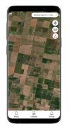
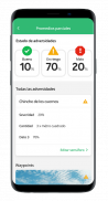
Visualization and analysis are central to the functionalities offered by SIMA. The app provides a range of tools, including tables, graphs, and interactive maps, to help users interpret the data collected in the field. These features make it easier to understand trends and conditions over time, allowing for better decision-making. The web-based platform complements the mobile app, providing users with access to their data from various devices.
SIMA also facilitates the generation and sharing of reports. This feature allows users to automatically communicate the status of their agricultural batches and the outcomes of their decisions via work orders. This streamlined reporting process reduces the time and effort involved in manual reporting, enabling agricultural professionals to focus more on field management.
One of the notable aspects of SIMA is its integration with satellite imaging capabilities. Users can enhance their monitoring processes by utilizing satellite images obtained through NDVI (Normalized Difference Vegetation Index), GNDVI (Green Normalized Difference Vegetation Index), and RGB (Red Green Blue) indicators. These tools allow users to visualize different layers of crop health and compare various stages of growth, providing insights into crop conditions.
The app promotes precision in agricultural practices by standardizing data collection methods. This unification of criteria across teams ensures traceability and effective planning. By using SIMA, agricultural professionals can audit work and personnel systematically, leading to improved operational efficiency. The app also emphasizes process optimization, minimizing the time spent on batch work and the reporting effort required.
SIMA's real-time monitoring capabilities lead to more accurate diagnoses of batch conditions. This precision translates to significant reductions in agrochemical applications, promoting cost savings and a lower environmental impact. By making informed decisions based on reliable data, users can improve the sustainability of their agricultural practices.
Another important aspect of SIMA is its ability to interface with other agricultural software systems. The app imports batch and crop data from Finnegans, allowing for seamless synchronization between the two platforms. Additionally, SIMA exports monitoring maps to the FieldView platform, enabling users to generate automatic harvest progress reports for each batch. This interconnectedness enhances the overall utility of SIMA, making it a vital tool for modern agricultural management.
The user interface of SIMA is designed for ease of use, ensuring that users can navigate the app and access its features without extensive training. The app's layout is intuitive, allowing users to quickly collect data and generate reports, which is essential in a fast-paced agricultural environment. The ability to access data from both mobile and web platforms adds to the flexibility of the app, catering to the diverse needs of agricultural professionals.
SIMA serves as an integral solution for agricultural monitoring, employing methodologies that have been verified by established agricultural institutions and researchers. This commitment to using scientifically-backed practices enhances the credibility of the data collected and reported through the app, making it a reliable choice for monitoring crops.
Incorporating the features of SIMA into agricultural practices not only aids in effective monitoring but also fosters a collaborative environment among team members. The standardized approach to data collection and reporting ensures that all team members are aligned in their understanding of field conditions.
The application ultimately provides a comprehensive toolkit for agricultural monitoring, emphasizing data collection, visualization, and reporting. By utilizing SIMA, users can enhance their operational efficiency, make informed decisions, and promote sustainable agricultural practices. The integration of multimedia and satellite imaging further enriches the monitoring experience, making SIMA a valuable asset for anyone involved in the agricultural sector.
For further information, you may visit the official website or contact customer support to explore more about SIMA and its functionalities.
SIMA Monitoreo de Cultivos - Version 4.5.6
(31-01-2025)SIMA Monitoreo de Cultivos - APK Information
APK Version: 4.5.6Package: com.voy.simaLatest Version of SIMA Monitoreo de Cultivos
Other versions


 3.55
3.55
 3.17
3.17


Apps in the same category


